Calculating Global Coordinates
by
Fluen
This tutorial is a thorough and in-depth explanation on the global
coordinates of the level editor - partly meant as a reference. However,
if you are only interested in how to use the lens flare, you may safely
skim through this tutorial as you only need a cursory overview of this
information to make a fairly nice lens flare - just go to the last part
of this tutorial, where I have made the 'recipe' for calculation of the
coordinates (written in red).
I will explain all I have discovered about the LensFlare-command in the
tutorial:
How to set up a Global Lens Flare
Global coordinates and how to calculate them
Look at the coordinates shown when FlyCheat is enabled and F1 is
pressed:
Thanks to some fortunate coincidences involving a cramped room with
blocks to climb, a fixed camera, a target nullmesh and Lara fooling
around in a jeep (but not all of it at the same time), I discovered,
that the line:
p aaaaa,-bbbb,ccccc is the set of coordinates for
the camera,
while
t ddddd,-eeee,fffff is the set of coordinates for
the camera target (usually
Lara) and
r gg is the room number (but I guess most of us knew that already).
(That would explain the letters: p = point of view, t = target and r =
room.)
I suspect that Lara's heart or something close by is the centre of her
coordinates. Hold F1 while she sits in the jeep and notice that when she
changes gear from forwards to backwards, the middle coordinate
'decreases' (the negative number becomes a bit smaller). So the centre
of her coordinates must be a part of her which moves during this
process.
There is room for one hundred blocks in either direction in the global
editor room.
Some block climbing showed, that a block is 1024 * 1024 in global
coordinates. And finally one click is 256 - four clicks are 1024, so the
raised block has the same dimensions on all sides.
Be aware that height is negative upwards: If
you raise a block four clicks from zero level, the height coordinate
goes from 0 to -1024.
I'll use the coordinate description as shown below:
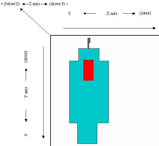
Just to add to the confusion, there is a non usable zone one block wide
all around the edge of the level editor window. Try to place a room in
one of the corners and you will notice that you can't get your room all
the way out to the edge.
When you place a room as far upwards and left as possible and then click
the upper- and leftmost block in that room, the (X, Y)-data for that
block will say 'Selected Block [ X:0 Y:0 ]'.
But the global coordinates start counting from the edge of the editor
window,
so the non usable zone counts for the first 1024 in both the X- and the
Y-direction and the global coordinates for the block with the
editor-coordinates X = 0, Y = 0 (the one you clicked) will be Xglobal=
1024, Yglobal =
1024.
It also means that the X- and Y-coordinates in the level editor window
go up to 104448 (100 blocks plus 2 unusable blocks - all multiplied with
1024).
Here is an example taken from the Playable Tutorial Level on how to
calculate the global coordinates for a specific block:
I chose this Room:
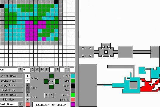
And in there I highlight a block:
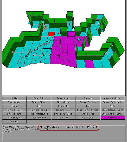
The red 'square' accentuates the coordinates for this particular block.
The first piece of information is general for the Mid Room: 'Floor: -16
Ceiling: -8' and it uses clicks.
This is the first challenge! This data always gives you the lowest level
of the floor and the highest level of the roof in the chosen room. Try
to lower just one
block in a room with a levelled floor (use the fresh room the editor
always presents when opened) and you will see that the
'Floor:'-information lowers with this one block even though the rest of
the floor stays in one place.
The same is the case for the roof. If you raise just one block in the
roof, the 'Roof:'-information will raise with it.
I have made things easy for myself by picking a block which is level
with the lowest part of the floor. So I already know that its height is
-8 clicks. If I needed to know the click-height of another block, I
would have to either raise another block from the floor or lower one
from the roof and count the clicks until it had the same height as the
block I was examining.
Ok, each click is 256 in global coordinates. This block is below zero
level so it has a positive value. All I have to do is to multiply 256
with 8 (forget about the negative sign):
Zglobal =
8 * 256 = 2048
Assuming the height for the above block had been above zero, say +11, I
would have done the same calculation:
Zglobal =
11 * 256 = 2816 and because it would be above zero level I would put a
negative sign in front of it, so +11 clicks are -2816 in global
coordinates.
When I do height calculations I only work with the numerical value (the
number itself) and add the negative sign afterwards if the block is
above zero level.
Now the X- and Y-coordinates:
They are read directly from 'Selected Block [ X:72 Y:31 ]'. But I have
to add one (1) to either number because of the non usable zone around
the rim of the level area before I can multiply each with 1024.
Xglobal =
(72 + 1) * 1024 = 73 * 1024 = 74752
Yglobal =
(31 + 1) * 1024 = 32 * 1024 = 32768
The general rule is then:
Xglobal =
(X-coordinate from the editor + 1) * 1024
Yglobal =
(Y- coordinate from the editor + 1) * 1024
Zglobal =
height in clicks (must be examined closer and forget about any negative
sign) * 256, and add a negative sign to the final value, if the height
is above zero level
Normally, you don't have to use such precision when you work with the
lens flare. The command for the lens flare used in Coastal Ruins from
Tomb Raider 4 is:
LensFlare = 250000, -32000, 110000, 128, 96, 0 - not very precise,
right?
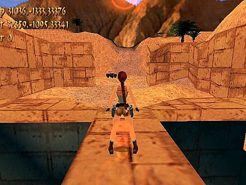
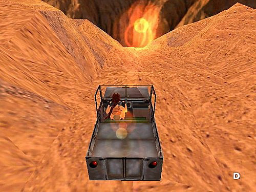
So the exact coordinates are only necessary if it is important for you
to be able to see the lens flare in a very specific place. The picture
below shows that I wanted it to appear at the same level as the road
Lara is driving along. With the road being only three blocks wide,
precision is needed.
This leads to the exact order of the coordinates and I must say that it
is the strangest coordinate system I have ever encountered. There must
have been a compelling reason for this coordinate system when the Tomb
Raider Editor was designed (or a wicked devil doing the program design).
The coordinates for the LensFlare-command are:
LensFlare = Y,Z,X,red,green,blue -
no wonder, it's confusing!
The same order is used for the coordinates you get when you use F1:
p yyyyy,-zzzzz,xxxxx
t yyyyy,-zzzzz,xxxxx
r nn (= no.)
As an example I suggest you start TRLE and let Lara stay on one spot
while you hold F1. If she crouches, the only coordinates that change are
the middle coordinates in the p- and the t-line, because Lara only
changes her position in height (the t-line) and so the camera aims lower
to follow her (the p-line). Remember, Z is height.
Next, climb onto a block so Lara faces exactly north (you know her
orientation is right, when you enter the inventory and the compass
needle is transparent - it is the red compass needle that must point
north). Hold F1 and let Lara roll and notice that the first coordinates
in the p- and the t-line stay calm, while the others go crazy.
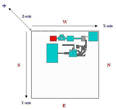
The real compass directions
Here I have to add something about compass directions. The manual that
comes with the level editor says that the upward edge of the editor
window is north. That
is wrong!
The real compass
directions as they work in-game are:
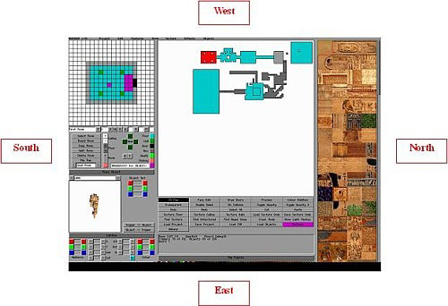
The X-coordinate runs from south to north and the Y-coordinate runs from
west to east. If you want the sun (i.e. the lens flare) to rise in the
east and set in the west, you must be aware of this. But the Tomb Raider
games take place out of our world, so it is not mandatory. For instance,
the sunset in Coastal Ruins takes place in the east, so what?
So when Lara does the rolling around on the block mentioned above, she
only moves along the X-axis, while remaining at the same 'Y-height'. And
that is why the first coordinate (the Y) in both lines doesn't change.
To make things clear, here is an easy to understand diagram showing the
relationship between compass directions and global coordinates: